
Why Drone Photography Is a Game-Changer for Southern Utah Real Estate Listings
Southern Utah isn't like anywhere else in the country. Drone photography doesn't just show a property from above — it tells the whole story of where that property lives. Here's why aerial matters more here than almost anywhere.
There's a reason drone photography has become one of the most requested add-ons at Cedar Real Estate Media. In most markets, aerial shots are a nice-to-have. In Southern Utah, they're practically essential — and once you see the difference, you'll understand why.
The Backdrop Is the Selling Point
When someone buys a home in Cedar City, St. George, Kanab, or Brian Head, they're not just buying the house. They're buying the view from the back porch. They're buying the red rock cliffs visible from the kitchen window. They're buying proximity to Zion, Bryce Canyon, and Cedar Breaks. They're buying a lifestyle that doesn't exist anywhere else in the country.
A ground-level photo can't show any of that. A drone can.
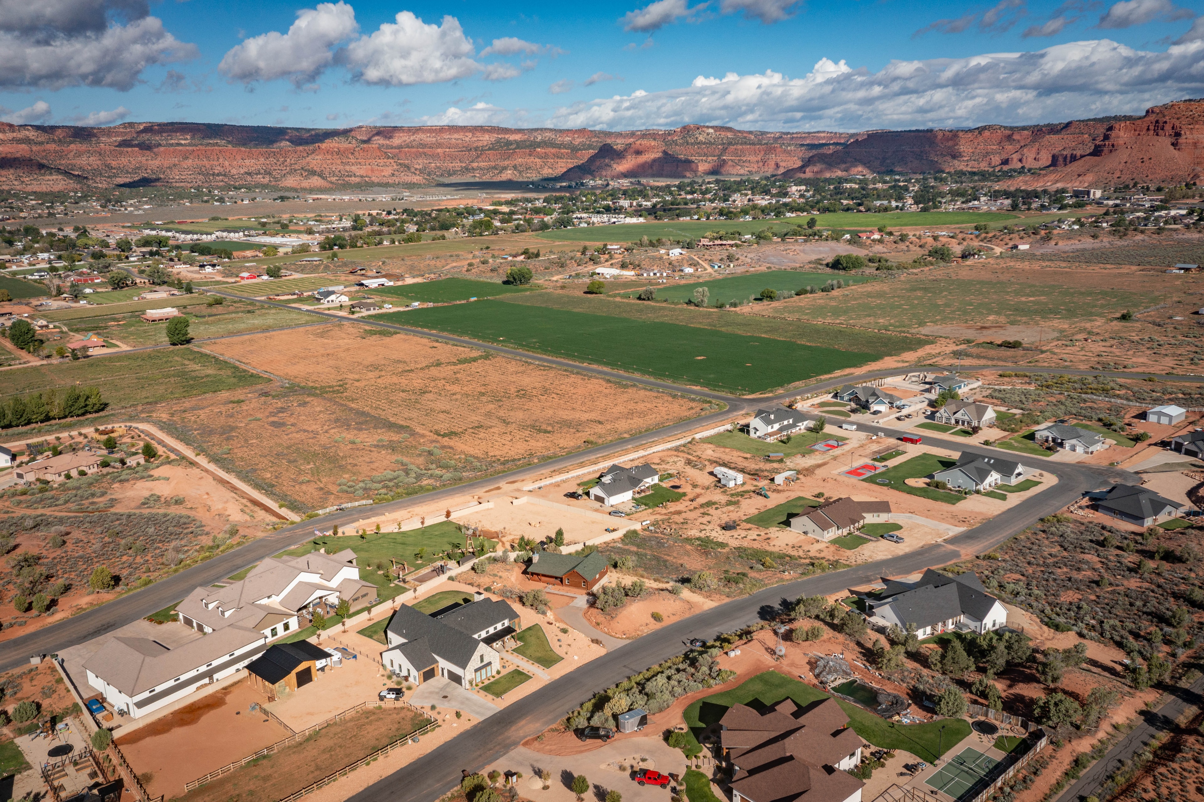
Lee Webb's aerial photography at Cedar Real Estate Media is specifically designed to capture that context — the relationship between the property and the landscape surrounding it. Whether it's a cabin perched above a canyon, a ranch with open desert stretching to the horizon, or a subdivision with Navajo sandstone formations as the backdrop, drone shots communicate what makes Southern Utah properties genuinely unique.
What Drone Photography Shows That Ground Shots Can't
The Surrounding Environment
Buyers relocating from out of state — and a significant portion of Southern Utah buyers are — often can't visit before making an offer. Aerial photography gives them a true sense of the neighborhood, the lot size, the proximity to open land, and what's around the property in every direction.
A drone shot of a Kanab vacation rental doesn't just show the cabin. It shows the red rock ridgeline behind it, the open sky above it, and the quiet rural setting that makes it worth booking. That context sells.
Lot Size and Land Features
Southern Utah properties often sit on larger lots with features that ground photography simply can't capture — horse pastures, detached workshops, RV parking, irrigated land, orchard trees, or direct access to trails and open BLM land. Aerial shots make all of that visible in a single frame.

Proximity to Landmarks and Amenities
Is the property five minutes from Zion's east entrance? A short drive from Brian Head ski resort? Walking distance from downtown Cedar City's Main Street? Drone photography can show that proximity in a way that no map screenshot or written description can match.
Curb Appeal at Scale
A wide aerial shot of a well-maintained property — clean roofline, manicured landscaping, good lot positioning — communicates pride of ownership in a way that resonates with buyers before they ever step inside.
Why Southern Utah Specifically Demands It
Most real estate markets have relatively neutral surroundings — subdivisions, flat terrain, similar homes on similar lots. Aerial photography in those markets is a differentiator, but it's not transformative.
Southern Utah is different. The landscape here is dramatic, varied, and genuinely spectacular. Red sandstone formations. Volcanic plateaus. High-elevation pine forests. Desert valleys with 100-mile views. When a property sits inside that kind of scenery, not showing it from the air is leaving the most compelling part of the listing on the table.
At Cedar Real Estate Media, Lee Webb shoots drone photography as a standard add-on to any package — and for vacation rentals, cabins, and rural properties in Kanab, Brian Head, and the surrounding areas, it's one of the first things we recommend.
FAA-Certified, Fully Insured
All drone photography at Cedar Real Estate Media is flown by Lee Webb under an FAA Part 107 certification. That matters for two reasons: the shots are legal and properly permitted, and the quality reflects professional training — not a consumer drone flown by someone who just bought one off Amazon.
Every aerial shoot is also fully insured, which some listing agents and brokerages require before allowing drone photography on a property.
What's Included in a Drone Add-On
When you add aerial photography to a Cedar Real Estate Media shoot, you get:
- High-resolution still photos from multiple altitudes and angles
- Establishing shots that show the property in its full landscape context
- Detail aerials of lot features, outbuildings, and land characteristics
- Delivery through Aryeo — the same platform that connects directly to your Zillow Pro account for Showcase listings
Drone footage can also be incorporated into a video walkthrough, giving you a cinematic opening sequence that starts from above and pulls into the property. It's one of the most effective ways to open a listing video.
Ready to Add Aerial to Your Next Listing?
If you have a listing coming up in Cedar City, St. George, Kanab, Brian Head, or anywhere in Southern Utah, drone photography is one of the highest-ROI additions you can make to your marketing package.
Book your shoot with Cedar Real Estate Media and add aerial at checkout — or call Lee directly at (714) 240-1200 to talk through what makes sense for your specific property.
The landscape here is unlike anywhere else. Your listings should show it.
Cedar Real Estate Media serves Cedar City, St. George, Kanab, Brian Head, and surrounding Southern Utah communities. All drone photography is FAA Part 107 certified and fully insured.
Explore Topics
Written by
Lee Webb — Cedar Real Estate Media
Content creator and writer sharing insights and stories.

